Sunday, January 24, 2016

Sanur, Bali, Indonesia: Not a snore of a run

Date: December 31, 2015     
Time: 8:20am // 0820 "pagi."
Weather: Mostly sunny, humid - about 90 F, or 32 Celsius
Terrain: Smooth to rough cobble stone, some pavement, some sand (hard and soft).
Difficulty: Easy (Moderate in heat/humidity)                        
Distance: ~3 miles                     
Shoes:  Nike Volmero 9            
Bonus: Finding a glass death star wedding chapel.

Friendliness of Runners Rating (F.O.R.R. or FORR Score):  1/2 - 50% (*see explanatory post)

Runners Engagement Score (RES): 7/10 [**see explanatory post)

"Sanur is a snore." A common description of Sanur, Bali (on the east coast opposite the more popular and glitzy Seminyak) is that it is not only a snore, but where the retirees go to lounge.  While the later is certainly true, we were pleasently surprised by Sanur's wide beaches, easy swimming, and great running and walking path.  For a one night stay before heading up to Ubud for New Year's celebrations, it was good for this relative newcomer to Bali to see a different part of the very diverse island.

The "Death Star" Wedding Chapel.
From just about anywhere along Jalan (Street) Danau Tamblingan, you can dash through a hotel or find a side street that goes to the beach.  There, the aptly named Jalan "Sanur Beach Street Walk" can be accessed and run in either direction north or south.   I recommend the area north of Hotel Griya Santarian (where we stayed - an okay place, but a bit shabby inside and prone to mosquitos) for better running space and footing.  That said, anywhere north of the Fairmont up to the top of the Street Walk will be blissful to a newcomer...with plenty of beach side umbrellas, palm trees, art sellers and beach side cafes and warungs.

Sanur Beach Street Walk - looking north.
Bring your camera...and extra water.  Although for a few rupiah, you can stop at several small shops along the path for bottled water or other drinks (did someone say Bintang?).

A few more pix...

Sanur beach.  Hard or soft sand.
Guardian lobster.

Good stretches of the path are under dappled sunlight...

Plenty of shops with refreshing drinks along the running path.

This beachside glade is apparently an oasis in the evening.
Beachside "post-run" massage widely available.

After the wicked humidity, a dip in the pool is a must.


Tuesday, September 9, 2014

Track Town USA, Eugene, Oregon: Animal House/"Pre" Trails Loop

Date: September 8, 2014     
Time: About 4:30pm.
Weather: Mostly sunny, apx 78 degrees fahrenheit
Terrain: Campus paved walks, cement trails, bark dust trails.
Difficulty: Easy                        
Distance: ~3 miles                     
Shoes:  Nike+ Lunarfly 1.5 "Ducks" Version            
Bonus: Discovering Steve Prefontaine's old running trails

Johnson Hall: Beware the horses within
stricken by heart attacks
Friendliness of Runners Rating (F.O.R.R. or FORR Score):  3/3 - 100% (*see explanatory post)

Runners Engagement Score (RES): 11/10 (It is Track Town USA...)  [**see explanatory post)

I failed to adequately explore Eugene as a runner during my college years there.  Frankly, it is embarrassing that only on this trip did I discover Steve Prefontaine's old running paths on the north banks of the Willamette River.  But in failure comes gained wisdom so they say.

At the invitation of my old college alma mater, I was back in Eugene for both an Oregon football game (we won, thankfully, against a very good Michigan State team) and for a visit with faculty and staff of the Clark Honors College and the Law School.  With an extra hour on my hand before needing to catch my flight, I donned my running shoes and headed out from the central campus.

Helpful signs along the path from campus.

This is an easy route for anyone to take - 30 minutes, mostly flat, and with a half way point that that can be extended for longer distances easily once you get to the warren of paths on the north banks of the Willamette.  Start at "Johnson Hall" on the campus, head north, push past the Mill Race waterway, and then run over the Willamette foot bridge (ask anyone you see - "how do I get to Autzen Stadium?") and you'll be among the many wandering paths and trails that Pre took on his runs.

A pure joy of an afternoon run.


The approach from the UofO Arts Studios area to the footbridge over the Willamette,
 underneath the railroad tracks.

Looking down on the Willamette River from the footbridge.  A good place to soak feet after a run too.

Pre's running trails, nicely maintained by www.OregonTrackClub.org.

One of the many areas north of the footbridge to catch one of Pre's old trails.
 [That is not Zack Galifianakis].

SE of Autzen, in Alton Baker park.  A great place for a breather on a run.

The southern route back, returning to campus over the footbridge.  Spencer's Butte, a popular hiking (and trial running) spot is at center, in the distance.

The end of the run at the Fishbowl, home of the famous "food fight" scene from Animal House.
And thankfully preserved in this phase of the remodeling of the student union.


Monday, September 1, 2014

Running Scores

After reading an article in Runner's World the other month, I decided I needed to add a rating or score to my runs.  Actually, two.

The first is what I call the "Friendliness of Runners Rating" or FORR Score.  It is a completely non-scientific rating of a location's friendliness, drawn from data derived on my run.  I wave at every runner I pass, and note the number of runners that wave back or acknowledge my greeting.  The FORR Score represents the percentage responding in some type of positive, community-oriented manner.  As Runner's World says, we exist in a community of runners.  Whether we choose to participate in that community and get some energy from that community is our own choice.

The second rating is the "Runner Engagement Score" or RES.  It is my equally unscientific assessment of whether a city, town or location is engaging to runners.  Criteria range from ease of getting out for a run, availability of paths or sidewalks, pollution levels, scenery, coolness of experience, etc.  

Readers are welcome to share their own scores or data.  

I've added these scores to my latest Oregon runs and will endeavor to do this for future posts.

Monday, June 23, 2014

St. James Park, London, United Kingdom

Grandma crushing her competition in a ping pong ball match in Victoria Embankment Gardens

Date: June 22, 2014     
Time: About 3:30 p.m.
Weather: Partly cloudy, somewhat sunny 
Terrain: City streets, park gravel paths
Difficulty: Easy                        
Distance: 3.6 miles                      
Shoes:  Nike+ Volmero 8s              
Bonus: Stumbling upon Victoria Embankment Gardens             

Jet lag can be cured by running.  I'm convinced of that. London offers an enhancement for this American - one must quickly adjust to all traffic habits being inverted.  Look right when one's instinct says left, and vice-versa.  Rewiring your brain while running clears those lagging cobwebs quite quickly.

I arrived in London yesterday via a red-eye flight, with scant chance to sleep.  After arriving at the hotel and getting a nap, I ventured out to run through a part of the city I've not spent much time in before: Covent Garden and the Victoria Embarkment area.

My path took me from the Waldorf hotel west, and on a lark I turned towards the Thames after seeing the Strand filled with tourists.  It was a good audible - I discovered stairs leading down to the Victoria Embankment and a sidewalk along the river.

There, I found Cleopatra's Needle (an obelisk that Khedive (Viceroy) Muhammad Ali gifted to Lord Nelson and Sir Ralph Abercromby in 1819), flanked by a pair of Egyptian sphinxes (one pictured at right).

Onwards, I passed the eye pleasing pedestrian "Golden Jubilee" pedestrian bridges, similar to another foot bridge I'd walked over many years ago in London (the Millennium bridge).
It is a quick few steps beyond these bridges to Big Ben and the Westminster area.  After a quick glance at one of the many handy map stands in the area, I decided to explore Victoria Tower Gardens, just south of the Houses of Parliament.

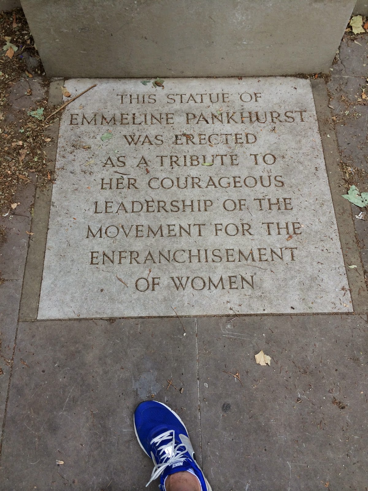
I'm glad I did.  My diversion led me to a quiet park watched over by a statue of Emmeline Pankhurst.  Only on my writing of this blog would I learn of her passionate (and occasionally violent) fight for women's suffrage in Britain.  One of her quotes captures her spirit quite well,"Window-breaking, when Englishmen do it, is regarded as honest expression of political opinion.  Window-breaking, when Englishwomen do it, is treated as a crime."  Her struggle would lead to the passage of the Representation of the People Act, in 1928, a few weeks after her passing, which gave electoral equality to men and women over age 21 for the first time in England's history.
The garden area itself is quite calming too.  Several families and couples out and about, rich green grass, and a bit of a breeze of the nearby Thames make for a bit of an oasis in downtown London.


I especially enjoyed the scene of these kids playing amidst a small tower on the grounds.  From there, I proceeded through the back trails of the Westminster Abbey area.

This path quickly took me to the St. James Park area, on the Whitehall side.  As I was running along the sidewalk waiting for a chance to dart across traffic into the park, I came upon this memorial to those lost in the 2002 Bali bombings.  The design is different than the surrounding buildings of Whitehall (government area), but I found the memorial to be thoughtfully done and a solemn reminder of that tragedy.  


From this spot, I did find a break in the traffic and ran across the lane into the park proper.  The park was filled with tourists and families and others, some lounging, others walking.

The remainder of my run in St. James took me over the bridge pictured below, near Buckingham Palace and under the Admiralty Arch:  


On the last leg back I even had a chance find of Sherlock's pub, sadly a football "free" zone:


All-in-all, a tremendous welcome to one of the most engaging and culturally rich cities in this World.

Saturday, May 17, 2014

Reva, Virginia


Date: May 9, 2014
Time: About 3:30 p.m.
Weather: Overcast but humid
Terrain: Gravel road, some small hills
Difficulty: Easy-Moderate
Distance: 2 miles, back and forth
Shoes:  Nike+ Volmero 8s
Bonus: Discovering a culvert stream and a field of horses and yellow flowers

My father-in-law passed away last fall.  One of his favorite places in this world is the family plot of land near Reva, Virginia - pictured above (the picture from a brisk clear day this last winter).  I went running on the packed gravel road leading to the property.  It was the day before his "celebration of life," which we finally held after many months of grieving and confusion and waiting for the weather to turn better.

The route I picked was on Desert Road (State Route 606), just off of Hoover Road (State Route 609) running west from Route 29 (Culpepper to Charlottesville leg).  The route is a relatively quiet one through a collection of occasional houses tucked behind trees on large acre, wooded plots.  A reasonable quick run if you are in the area doing wine tasting in the area (Ducard, a family favorite is nearby).

Throwing shadows on a somewhat overcast day.
During a sunlight flash through the gathering clouds
I have never run on this road.  Doug and I would come out and do work on the farm, or my wife and I would be dashing out to the farm to meet him after he had been working since sunrise.  We usually only drove over its gravel and around its serpentine curves.  It was good to finally paw through this area that had meant so much to him.

It was also good to find some new sights - like this blossoming tree.


I was out at the farm to help guide the setup of a tent for Doug's party the next day.  After that and some unloading of party gear, the run was a good chance to be quiet, think of him, and remember our time out at what he called "the farm."

The property with the horses (which promptly fled as I walked up the lane) and the amazing blanket of yellow flowers dusting the fields around the house.

Running back from my turn around point, I was struck by the beauty of this lane.  Diffused light blowing through the canopy of fresh green foliage made me feel just a bit younger as I ran back.


Desert Road, an arc of gravel and dirt through wooded plots.
The entrance to the Courtney property.
Doug - ever the patriot - marked the land with a simple American flag.
If you run this route, feel free to park your car just inside the gate pictured above.  It is comprised of a simple chain that you can drop on the ground and drive over.  Please replace it when you depart.